Fires Devastate New Guinea Amid Drought
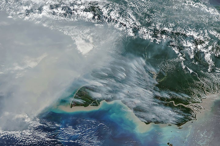
New Guinea, the second-largest island globally, is experiencing severe wildfires as a result of an ongoing drought exacerbated by a potent El Niño event. The island is home to a rich diversity of flora across its various ecoregions, which include tropical rainforests and savannas. However, from September to October 2026, drought conditions led to extensive fires that blanketed significant areas of the island in smoke for several weeks.
Satellite Images Reveal Severity of the Situation
The NOAA-20 satellite’s VIIRS (Visible Infrared Imaging Radiometer Suite) captured alarming images of thick smoke emanating from the southern regions of New Guinea on October 11, 2026. The resulting air pollution has been severe enough to impact transportation, leading to flight cancellations and school closures. Local authorities recommended that vulnerable populations, such as children and the elderly, wear masks to mitigate health risks.
Robert Field, an associate research scientist at NASA’s Goddard Institute for Space Studies, commented on the dire air quality, stating, “It’s a horrible situation.” He noted that while some smoke may be carried into the upper atmosphere by thunderstorms, much of it remains close to the ground, contributing to air quality issues.
Record Carbon Emissions from Fires
According to the Global Fire Emissions Database (GFED), fires in Papua New Guinea had emitted nearly 32 megatons of carbon by October 19, 2026, marking a record high for that time of year. Guido van der Werf, a fire scientist at Wageningen University & Research, indicated that emissions are on track to surpass the total for 2015 and potentially exceed those from 1997, another year marked by severe fires.
On the Indonesian side of the island, known as West New Guinea or Indonesian Papua, carbon emissions also reached over 35 megatons, ranking as the third highest after 2015 and 1997. Van der Werf developed GFED, which utilizes satellite data and other metrics to assess fire activity and emissions trends over three decades.
Impact of El Niño on Weather Patterns
The unusually dry conditions across New Guinea are primarily linked to the El Niño phenomenon, which disrupts rainfall patterns. The National Weather Service in Papua New Guinea reported that the southernmost region of the island experienced over 90 consecutive days without rain. Some areas have recorded precipitation levels as low as 5 to 10 percent of normal since August, leading to crop failures, water shortages, and disruptions in education.
Human Activity Contributes to Wildfires
Research indicates that most fires in New Guinea are human-caused, with common practices including crop burning, pasture management, deforestation, and land clearing. Under dry conditions, these managed burns can easily escalate into uncontrolled wildfires, particularly in the island’s southern regions.
Yang Chen, an associate researcher at the University of California, Irvine, highlighted the heightened fire activity in Papua New Guinea and Eastern Indonesia this year, noting that Papua has become a new frontier for deforestation in Indonesia.
Deforestation Trends in Indonesian Papua
Over the past two decades, significant land has been cleared in Indonesian Papua for industrial agriculture, including oil palm and pulpwood plantations, as well as for urban expansion and mining activities. Data from Global Forest Watch shows that 27,000 hectares of primary forest were lost in 2025, nearly double the amount cleared in 2024 and representing the highest loss since 2017.
In contrast, fire activity in Sumatra has remained relatively low in comparison to previous drought years, partly due to the extensive development in the region. Many plantation areas have private fire brigades to protect their assets, while uncontrolled fire occurrences are more common in unmanaged lands and near primary forest edges.
Researchers predict that the ongoing fires will continue until the arrival of the wet season’s heavy rains in southern New Guinea, typically expected in early November.
This report is based on information provided by NASA Earth Observatory and various scientific studies.
Source: NASA